Soubor:Azores satellite photo-NASA.jpg

Velikost tohoto náhledu: 800 × 600 pixelů. Jiná rozlišení: 320 × 240 pixelů | 640 × 480 pixelů | 1 024 × 768 pixelů | 1 280 × 960 pixelů | 1 600 × 1 200 pixelů.
Původní soubor (1 600 × 1 200 pixelů, velikost souboru: 99 KB, MIME typ: image/jpeg)
| Tento soubor pochází z Wikimedia Commons. Níže jsou zobrazeny informace, které obsahuje jeho tamější stránka s popisem souboru. |
Popis
| Popis |
Deutsch: Satellitenfoto der Azoren
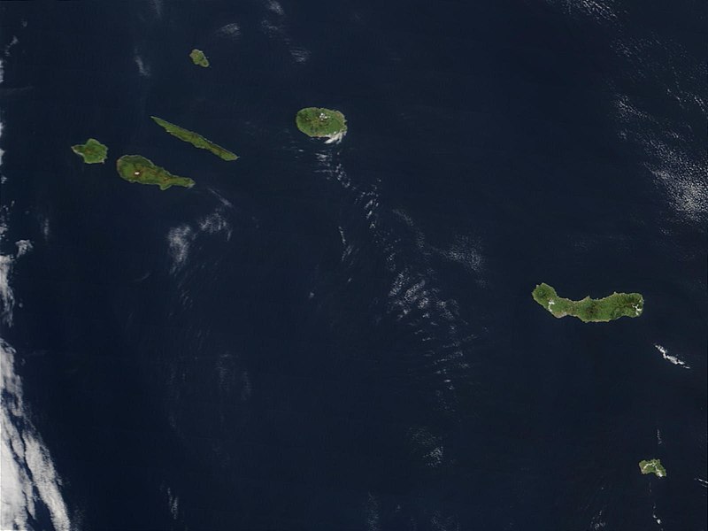
English: Original caption: Hundreds of miles off the coast of Portugal, the nine islands of the Azores chains are stretched out over the Atlantic Ocean. This Moderate Resolution Imaging Spectroradiometer (MODIS) image from the Terra satellite on May 1, 2003, shows seven of the nine islands: (from left to right) Faial, Pico, Sao Jorge, Graciosa (north), Terceira, Sao Miguel, and Santa Maria. |
| Datum | |
| Zdroj | visibleearth.nasa.gov (VE Record ID: 25535) |
| Autor | Jeff Schmaltz, MODIS Rapid Response Team, NASA/GSFC |
| Další verze | cropped and annotated version: File:Satellite image of The Azores in May 2003.jpg |
Licence
| This file is in the public domain in the United States because it was solely created by NASA. NASA copyright policy states that "NASA material is not protected by copyright unless noted". (See Template:PD-USGov, NASA copyright policy page or JPL Image Use Policy.) | ||
 |
Warnings:
|
Historie souboru
Kliknutím na datum a čas se zobrazí tehdejší verze souboru.
| Datum a čas | Náhled | Rozměry | Uživatel | Komentář | |
|---|---|---|---|---|---|
| současná | 20. 5. 2007, 11:28 | | 1 600 × 1 200 (99 KB) | Yonidebest | {{Information |Description='''Original caption:''' :''Hundreds of miles off the coast of Portugal, the nine islands of the Azores chains are stretched out over the Atlantic Ocean. This Moderate Resolution Imaging Spectroradiometer (MODIS) image from the T |
Využití souboru
Tento soubor nepoužívá žádná stránka.
Globální využití souboru
Tento soubor využívají následující wiki:
- Využití na an.wikipedia.org
- Využití na ast.wikipedia.org
- Využití na ca.wikipedia.org
- Využití na en.wiktionary.org
- Využití na eo.wikipedia.org
- Využití na es.wikipedia.org
- Využití na eu.wikipedia.org
- Využití na gl.wikipedia.org
- Využití na la.wikipedia.org
- Využití na lij.wikipedia.org
- Využití na li.wikipedia.org
- Využití na mwl.wikipedia.org
- Využití na nl.wikipedia.org
- Využití na oc.wikipedia.org
- Využití na pl.wiktionary.org
- Využití na pt.wikipedia.org
- Využití na sv.wikipedia.org
- Využití na www.wikidata.org
- Využití na zea.wikipedia.org