Soubor:Australian desert ESA345627.jpg

Původní soubor (1 680 × 1 920 pixelů, velikost souboru: 4,7 MB, MIME typ: image/jpeg)
| Tento soubor pochází z Wikimedia Commons. Níže jsou zobrazeny informace, které obsahuje jeho tamější stránka s popisem souboru. |
Popis
| Popis |
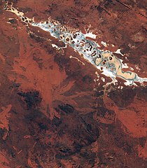
English: This spectacular image captured by Sentinel-2A on 13 July features Lake Amadeus, in Australia’s Northern Territory.
It shows the variety of the sandy, rocky and salty formations within the lake. Around 180 km long and 10 km wide, Amadeus is the largest salt lake in the Northern Territory, just 50 km north of Uluru/ Ayers Rock. Lake Amadeus contains up to 600 million tonnes of salt. However, harvesting is not feasible because of its remote location. Owing to the aridity of the area, the surface of Lake Amadeus is often a dry salt crust. When rainfall is sufficient, it becomes part of an east-flowing drainage system that eventually connects to the Finke River. A UNESCO World Heritage Site and one of Australia’s most recognisable landmarks, Uluru/Ayers Rock is a large sandstone rock formation standing 348 m high, rising 863 m above sea level and with a circumference of 9.4 km. Also clearly visible in the lower-central part of the image are the Petermann Ranges. These mountains run 320 km across the border between Western Australia and the southwest corner of the Northern Territory. Their highest point is 1158 m above sea level. The range was formed about 550 million years ago as compression folded a section of Earth’s crust. Launched in June, Sentinel-2A – the most recent satellite in orbit for Europe’s Copernicus programme – provides detailed information about Earth’s land cover and inland water bodies, helping us to understand Earth’s varied landscape. This image is also featured on the Earth from Space video programme. |
| Datum | |
| Zdroj | http://www.esa.int/spaceinimages/Images/2015/09/Australian_desert |
| Autor | European Space Agency |
| Svolení (Užití tohoto souboru) |
Copernicus Sentinel data (2015)/ESA,CC BY-SA 3.0 IGO |
| Title | Australian desert |
| Set | Earth observation image of the week |
| System | Copernicus |
| Mission | Sentinel-2 |
| Location | Australia |
| Activity | Observing the Earth |
| Keywords | Deserts; Lakes; Satellite image |
| Pozice objektu | | Tento snímek a mnohé další na: OpenStreetMap |
|---|

Licence
- Dílo smíte:
- šířit – kopírovat, distribuovat a sdělovat veřejnosti
- upravovat – pozměňovat, doplňovat, využívat celé nebo částečně v jiných dílech
- Za těchto podmínek:
- uveďte autora – Máte povinnost uvést autorství, poskytnout odkaz na licenci a uvést, pokud jste provedli změny. Toho můžete docílit jakýmkoli rozumným způsobem, avšak ne způsobem naznačujícím, že by poskytovatel licence schvaloval nebo podporoval vás nebo vaše užití díla.
- zachovejte licenci – Pokud tento materiál jakkoliv upravíte, přepracujete nebo použijete ve svém díle, musíte své příspěvky šířit pod stejnou nebo slučitelnou licencí jako originál.
| Poznámky | K tomuto souboru existují poznámky: Prohlédnout si poznámky na Commons |
Historie souboru
Kliknutím na datum a čas se zobrazí tehdejší verze souboru.
| Datum a čas | Náhled | Rozměry | Uživatel | Komentář | |
|---|---|---|---|---|---|
| současná | 6. 5. 2017, 18:16 | | 1 680 × 1 920 (4,7 MB) | Fæ | == {{int:filedesc}} == {{information | description = {{en|1=This spectacular image captured by Sentinel-2A on 13 July features Lake Amadeus, in Australia’s Northern Territory. It shows the variety of the sandy, rocky and salty formations within the l... |
Využití souboru
Tento soubor nepoužívá žádná stránka.
Globální využití souboru
Tento soubor využívají následující wiki:
- Využití na ru.wikipedia.org