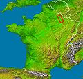
Soubor:Argonne localization.jpg

Velikost tohoto náhledu: 628 × 600 pixelů. Jiná rozlišení: 251 × 240 pixelů | 503 × 480 pixelů | 804 × 768 pixelů | 1 072 × 1 024 pixelů | 2 172 × 2 074 pixelů.
Původní soubor (2 172 × 2 074 pixelů, velikost souboru: 1,11 MB, MIME typ: image/jpeg)
Historie souboru
Kliknutím na datum a čas se zobrazí tehdejší verze souboru.
| Datum a čas | Náhled | Rozměry | Uživatel | Komentář | |
|---|---|---|---|---|---|
| současná | 16. 7. 2006, 15:52 |  | 2 172 × 2 074 (1,11 MB) | Laurent Deschodt | '''en :''' * '''Subject :''' Argonne country localization in France viewed by NASA Shuttle radar-imaging ; * '''Source :''' (map) [http://earthobservatory.nasa.gov/Newsroom/NewImages/images.php3?img_id=15360 NASA Earth Observatory] (modified) ; * '''Orig |
Využití souboru
Tento soubor používá následující stránka:
Globální využití souboru
Tento soubor využívají následující wiki:
- Využití na als.wikipedia.org
- Využití na be-tarask.wikipedia.org
- Využití na de.wikipedia.org
- Využití na el.wikipedia.org
- Využití na eo.wikipedia.org
- Využití na es.wikipedia.org
- Využití na fr.wikipedia.org
- Využití na hu.wikipedia.org
- Využití na it.wikipedia.org
- Využití na nl.wikipedia.org
- Využití na oc.wikipedia.org
- Využití na pl.wiktionary.org
- Využití na sv.wikipedia.org
- Využití na zh.wikipedia.org

