Soubor:Ardf map.png
Ardf_map.png (600 × 550 pixelů, velikost souboru: 430 KB, MIME typ: image/png)
| Tento soubor pochází z Wikimedia Commons. Níže jsou zobrazeny informace, které obsahuje jeho tamější stránka s popisem souboru. |
source/author
Popis
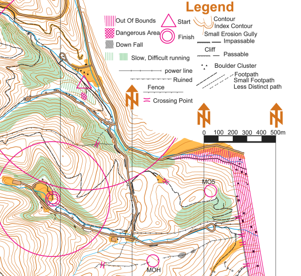
On this portion of an ARDF map, the start location is indicated by a triangle and the finish location is indicated by two concentric circles. The locations of two of the five transmitters are indicated on this version of the map with circles and the labels MOH and MO5 - on the versions of the map given to competitors, the locations of the transmitters are not indicated.
This map is a portion of the Cibola National Forest in the Sandia Mountains east of Albuquerque, New Mexico, USA. The map was used for the eighty meter competition of the Third IARU Region II ARDF Championship, August 5, 2005. This map is not created to International Orienteering Federation standards for orienteering maps.
The map was created in 2005 by Jerry Boyd of Albuquerque, New Mexico, with field checking by Gail Boyd, Taylor Boyd, Jack Stump, Scott Stevenson, and Jerry Boyd. Contact information for these individuals is available at the Albuquerque Transmitter Hunters archive copy at the Wayback Machine web site. This image of the map has been released under GFDL by its author, Jerry Boyd, and is used with permission.
A subsequent map of the same terrain has been created from scratch by professional mapmakers working on behalf of New Mexico Orienteers archive copy at the Wayback Machine. Work on that map began in 2005, after the completion of the 2005 IARU Region II ARDF Championship.
Licence
| Tento soubor podléhá licenci Creative Commons Uveďte autora-Zachovejte licenci 3.0 Unported Subject to disclaimers. | ||
| ||
| Tato licenční šablona byla k tomuto souboru přidána v rámci změny licencování. |

|
Tento dokument smí být kopírován, šířen nebo upravován podle podmínek Svobodné licence GNU pro dokumenty verze 1.2 nebo libovolné vyšší verze publikované nadací Free Software Foundation. Dokument nemá neměnné části ani texty na předním či zadním přebalu. Kopie textu licence je k dispozici v oddíle nazvaném GNU Free Documentation License. Subject to disclaimers. |
Historie souboru
Kliknutím na datum a čas se zobrazí tehdejší verze souboru.
| Datum a čas | Náhled | Rozměry | Uživatel | Komentář | |
|---|---|---|---|---|---|
| současná | 12. 3. 2006, 22:46 | | 600 × 550 (430 KB) | Greudin | == Summary == On this portion of an ARDF map, the start location is indicated by a triangle and the finish location is indicated by two concentric circles. The locations of two of the five transmitters are indicated on |
Využití souboru
Tento soubor používají následující 2 stránky:
Globální využití souboru
Tento soubor využívají následující wiki:
- Využití na en.wikipedia.org
- Využití na en.wikibooks.org
- Využití na en.wikiversity.org
- Využití na en.wikivoyage.org
- Využití na fr.wikipedia.org
- Využití na pl.wikipedia.org
- Využití na sk.wikipedia.org
- Využití na zh-yue.wikipedia.org
- Využití na zh.wikipedia.org