Soubor:Approximate extension of Alodia based on accounts of Ibn Hawqal.png

Velikost tohoto náhledu: 800 × 581 pixelů. Jiná rozlišení: 320 × 232 pixelů | 640 × 464 pixelů | 813 × 590 pixelů.
Původní soubor (813 × 590 pixelů, velikost souboru: 106 KB, MIME typ: image/png)
| Tento soubor pochází z Wikimedia Commons. Níže jsou zobrazeny informace, které obsahuje jeho tamější stránka s popisem souboru. |
Popis
| Popis |
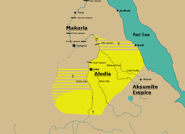
English: Initially based on map IX from the book "The Kingdom of Alwa" (see the first four versions of the map to see the faithful copy).[1] The original map had several problems, so I decided to modify it. 1) Zarroug had Alodia extend as far west as Darfur. However, there is still virtually no archaeological evidence supporting this assumption.[2] 2) The exact nothern border is still desputed; it is generally placed between Abu Hamad and the confluence of the Nile and the Atbara.[3] 3) Zarroug shows all regions west of the Nile as part of Alodia. However, the traveller Ibn Hawqal explicitly stated that parts of the region west of the White Nile were part of Makuria. The Nuba mountains were probably part of Alodia, hence I included stripes and a question mark for the area between the confluence of the two Niles and the Nuba mountains.[4] 4) There is little evidence that the Bayuda desert (between ed Debba and Omdurman) was part of either Makuria or Alodia.[5]
|
| Datum | |
| Zdroj | Vlastní dílo |
| Autor | LeGabrie |
Licence
Já, držitel autorských práv k tomuto dílu, ho tímto zveřejňuji za podmínek následující licence:
Tento soubor podléhá licenci Creative Commons Uveďte autora-Zachovejte licenci 4.0 International
- Dílo smíte:
- šířit – kopírovat, distribuovat a sdělovat veřejnosti
- upravovat – pozměňovat, doplňovat, využívat celé nebo částečně v jiných dílech
- Za těchto podmínek:
- uveďte autora – Máte povinnost uvést autorství, poskytnout odkaz na licenci a uvést, pokud jste provedli změny. Toho můžete docílit jakýmkoli rozumným způsobem, avšak ne způsobem naznačujícím, že by poskytovatel licence schvaloval nebo podporoval vás nebo vaše užití díla.
- zachovejte licenci – Pokud tento materiál jakkoliv upravíte, přepracujete nebo použijete ve svém díle, musíte své příspěvky šířit pod stejnou nebo slučitelnou licencí jako originál.
Historie souboru
Kliknutím na datum a čas se zobrazí tehdejší verze souboru.
| Datum a čas | Náhled | Rozměry | Uživatel | Komentář | |
|---|---|---|---|---|---|
| současná | 27. 11. 2018, 17:20 | | 813 × 590 (106 KB) | LeGabrie | Deleted stripes in Bayuda desert |
| 28. 10. 2018, 17:47 |  | 703 × 590 (114 KB) | LeGabrie | decreased width | |
| 15. 10. 2018, 14:51 |  | 813 × 590 (108 KB) | LeGabrie | Added Gash Delta | |
| 29. 9. 2018, 13:38 |  | 813 × 590 (108 KB) | LeGabrie | Extended the beams over the entire Bayuda | |
| 4. 9. 2018, 14:12 |  | 813 × 590 (111 KB) | LeGabrie | added question mark | |
| 4. 9. 2018, 13:59 |  | 813 × 590 (108 KB) | LeGabrie | Cut the beams in Darfur | |
| 1. 9. 2018, 02:55 |  | 813 × 590 (114 KB) | LeGabrie | Increased script size | |
| 1. 9. 2018, 02:51 |  | 813 × 590 (114 KB) | LeGabrie | small fix | |
| 1. 9. 2018, 02:49 |  | 813 × 590 (114 KB) | LeGabrie | Made it prettier | |
| 1. 2. 2018, 23:14 |  | 813 × 590 (155 KB) | LeGabrie | Added white beams and question marks to highlight the uncertainties of Zarroug's map. These uncertainties are: The extension into Darfur,the question of ownership of northern Kordofan and the beginning of Al-Abwab. The concrete amount of desert aside o... |
Využití souboru
Tento soubor používá následující stránka:
Globální využití souboru
Tento soubor využívají následující wiki:
- Využití na ar.wikipedia.org
- Využití na arz.wikipedia.org
- Využití na azb.wikipedia.org
- Využití na de.wikipedia.org
- Využití na en.wikipedia.org
- Využití na es.wikipedia.org
- Využití na fa.wikipedia.org
- Využití na fi.wikipedia.org
- Využití na fr.wikipedia.org
- Využití na id.wikipedia.org
- Využití na ms.wikipedia.org
- Využití na nl.wikipedia.org
- Využití na pt.wikipedia.org
- Využití na ru.wikipedia.org
- Využití na sl.wikipedia.org
- Využití na sr.wikipedia.org
- Využití na sv.wikipedia.org
- Využití na ta.wikipedia.org
- Využití na th.wikipedia.org
- Využití na tl.wikipedia.org
- Využití na uk.wikipedia.org
- Využití na vi.wikipedia.org
- Využití na zh.wikipedia.org