Soubor:Alps of France NASA A2002274 1240 250m.jpg

Velikost tohoto náhledu: 414 × 599 pixelů. Jiná rozlišení: 166 × 240 pixelů | 332 × 480 pixelů | 998 × 1 444 pixelů.
Původní soubor (998 × 1 444 pixelů, velikost souboru: 1,13 MB, MIME typ: image/jpeg)
| Tento soubor pochází z Wikimedia Commons. Níže jsou zobrazeny informace, které obsahuje jeho tamější stránka s popisem souboru. |
Popis
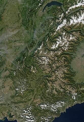
| Popis | The Alps march across these true-color MODIS images of Autumnal southern Europe. On either side of and above the Alps are the countries of (from left to right) France, Switzerland, Liechtenstein, Austria, and Slovenia, while below the Alps is Italy. The Mediterranean and Ligurian Seas sit to the west of Italy, while to the right is the Adriatic Sea. As the season progresses, snow begins to whiten the Alps. |
| Datum | NASA Visualization Date: 2002-10-26 (26 Oct 2002) |
| Zdroj | NASA Visible Earth: http://veimages.gsfc.nasa.gov/4465/Alps.A2002274.1240.250m.jpg - https://web.archive.org/web/20090624134426/http://visibleearth.nasa.gov/view_rec.php?id=4465 |
| Autor | Jacques Descloitres, MODIS Rapid Response Team, NASA/GSFC |
| Svolení (Užití tohoto souboru) |
Public domain: NASA |
| Další verze | high resolution image cropped |
Licence
| This file is in the public domain in the United States because it was solely created by NASA. NASA copyright policy states that "NASA material is not protected by copyright unless noted". (See Template:PD-USGov, NASA copyright policy page or JPL Image Use Policy.) | ||
 |
Warnings:
|
Historie souboru
Kliknutím na datum a čas se zobrazí tehdejší verze souboru.
| Datum a čas | Náhled | Rozměry | Uživatel | Komentář | |
|---|---|---|---|---|---|
| současná | 15. 3. 2010, 14:09 | | 998 × 1 444 (1,13 MB) | Charvex | {{Information |Description=Satellite photo of the Franch Alps |Source=NASA Visible Earth: http://veimages.gsfc.nasa.gov/4465/Alps.A2002274.1240.250m.jpg |Date=NASA Visualation Date: 2002-10-26 (26 Oct 2002) |Author=NASA Goddard Space Flight Center |Permis |
Využití souboru
Tento soubor používá následující stránka:
Globální využití souboru
Tento soubor využívají následující wiki:
- Využití na af.wikipedia.org
- Využití na de.wikipedia.org
- Využití na en.wikipedia.org
- Využití na eo.wikipedia.org
- Využití na et.wikipedia.org
- Využití na fr.wikipedia.org
- Využití na he.wikipedia.org
- Využití na id.wikipedia.org
- Využití na mk.wikipedia.org
- Využití na no.wikipedia.org
- Využití na pt.wikipedia.org
- Využití na uk.wikipedia.org
- Využití na xmf.wikipedia.org