Soubor:Afsluitdijk Netherlands Satellite Photo by Sentinel-2 30 June 2018.jpg

Původní soubor (4 305 × 3 847 pixelů, velikost souboru: 12,89 MB, MIME typ: image/jpeg)
| Tento soubor pochází z Wikimedia Commons. Níže jsou zobrazeny informace, které obsahuje jeho tamější stránka s popisem souboru. |
Popis
| Popis |
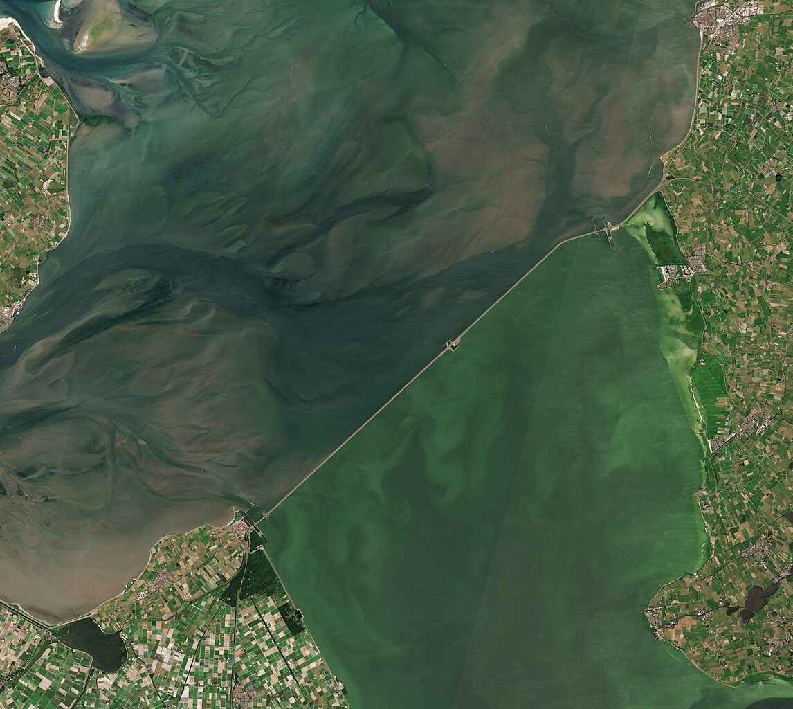
English: A satellite photo of the Afsluitdijk, The Netherlands, 30 June 2018. The Afsluitdijk changed the Zuiderzee into the IJsselmeer. To the north of the Afsluitdijk is the Wadden Sea, to the south is the IJsselmeer. Sensor: MSI on Sentinel-2A. Resolution: 10m. RGB Composites: True color, Band 4-3-2.
Nederlands: Een satellietfoto van de Afsluitdijk, Nederland, 30 juni 2018. De afsluitdijk veranderde de Zuiderzee in het IJsselmeer. Ten noorden van de Afsluitdijk is de Waddenzee, ten zuiden is het IJsselmeer. Sensor: MSI op Sentinel-2A. Resolutie: 10m. RGB-composieten: Ware Kleuren, Band 4-3-2. |
| Datum | |
| Zdroj | |
| Autor | Copernicus Sentinel-2, ESA |
.jpg)
Licence
- Dílo smíte:
- šířit – kopírovat, distribuovat a sdělovat veřejnosti
- upravovat – pozměňovat, doplňovat, využívat celé nebo částečně v jiných dílech
- Za těchto podmínek:
- uveďte autora – Máte povinnost uvést autorství, poskytnout odkaz na licenci a uvést, pokud jste provedli změny. Toho můžete docílit jakýmkoli rozumným způsobem, avšak ne způsobem naznačujícím, že by poskytovatel licence schvaloval nebo podporoval vás nebo vaše užití díla.
- zachovejte licenci – Pokud tento materiál jakkoliv upravíte, přepracujete nebo použijete ve svém díle, musíte své příspěvky šířit pod stejnou nebo slučitelnou licencí jako originál.

|
This image contains data from a satellite in the Copernicus Programme, such as Sentinel-1, Sentinel-2 or Sentinel-3. Attribution is required when using this image.
Uveďte autora: Contains modified Copernicus Sentinel data 2018
The use of Copernicus Sentinel Data is regulated under EU law (Commission Delegated Regulation (EU) No 1159/2013 and Regulation (EU) No 377/2014). Relevant excerpts:
Free access shall be given to GMES dedicated data [...] made available through GMES dissemination platforms [...].
Access to GMES dedicated data [...] shall be given for the purpose of the following use in so far as it is lawful:
GMES dedicated data [...] may be used worldwide without limitations in time.
GMES dedicated data and GMES service information are provided to users without any express or implied warranty, including as regards quality and suitability for any purpose. |
Historie souboru
Kliknutím na datum a čas se zobrazí tehdejší verze souboru.
| Datum a čas | Náhled | Rozměry | Uživatel | Komentář | |
|---|---|---|---|---|---|
| současná | 4. 7. 2023, 09:27 | | 4 305 × 3 847 (12,89 MB) | Artanisen | Uploaded a work by Copernicus Sentinel-2, ESA from Extracted from: North Holland with parts of Friesland and Flevoland by Sentinel-2 (Original 10m Res).jpg with UploadWizard |
Využití souboru
Tento soubor používá následující stránka:
Globální využití souboru
Tento soubor využívají následující wiki:
- Využití na af.wikipedia.org
- Využití na arz.wikipedia.org
- Využití na ast.wikipedia.org
- Využití na ca.wikipedia.org
- Využití na de.wikipedia.org
- Využití na en.wikipedia.org
- Využití na eo.wikipedia.org
- Využití na es.wikipedia.org
- Využití na fr.wikipedia.org
- Využití na fy.wikipedia.org
- Využití na hu.wikipedia.org
- Využití na ja.wikipedia.org
- Využití na ko.wikipedia.org
- Využití na nds-nl.wikipedia.org
- Využití na nds.wikipedia.org
- Využití na nl.wikipedia.org
- Využití na pl.wikipedia.org
- Využití na pt.wikipedia.org
- Využití na www.wikidata.org