Soubor:Aerial view of the Central Intelligence Agency headquarters, Langley, Virginia - Corrected and Cropped.jpg
Velikost tohoto náhledu: 800 × 356 pixelů. Jiná rozlišení: 320 × 142 pixelů | 640 × 284 pixelů | 1 024 × 455 pixelů | 1 280 × 569 pixelů | 2 560 × 1 138 pixelů | 5 523 × 2 455 pixelů.
Původní soubor (5 523 × 2 455 pixelů, velikost souboru: 7,57 MB, MIME typ: image/jpeg)
| Tento soubor pochází z Wikimedia Commons. Níže jsou zobrazeny informace, které obsahuje jeho tamější stránka s popisem souboru. |
Popis
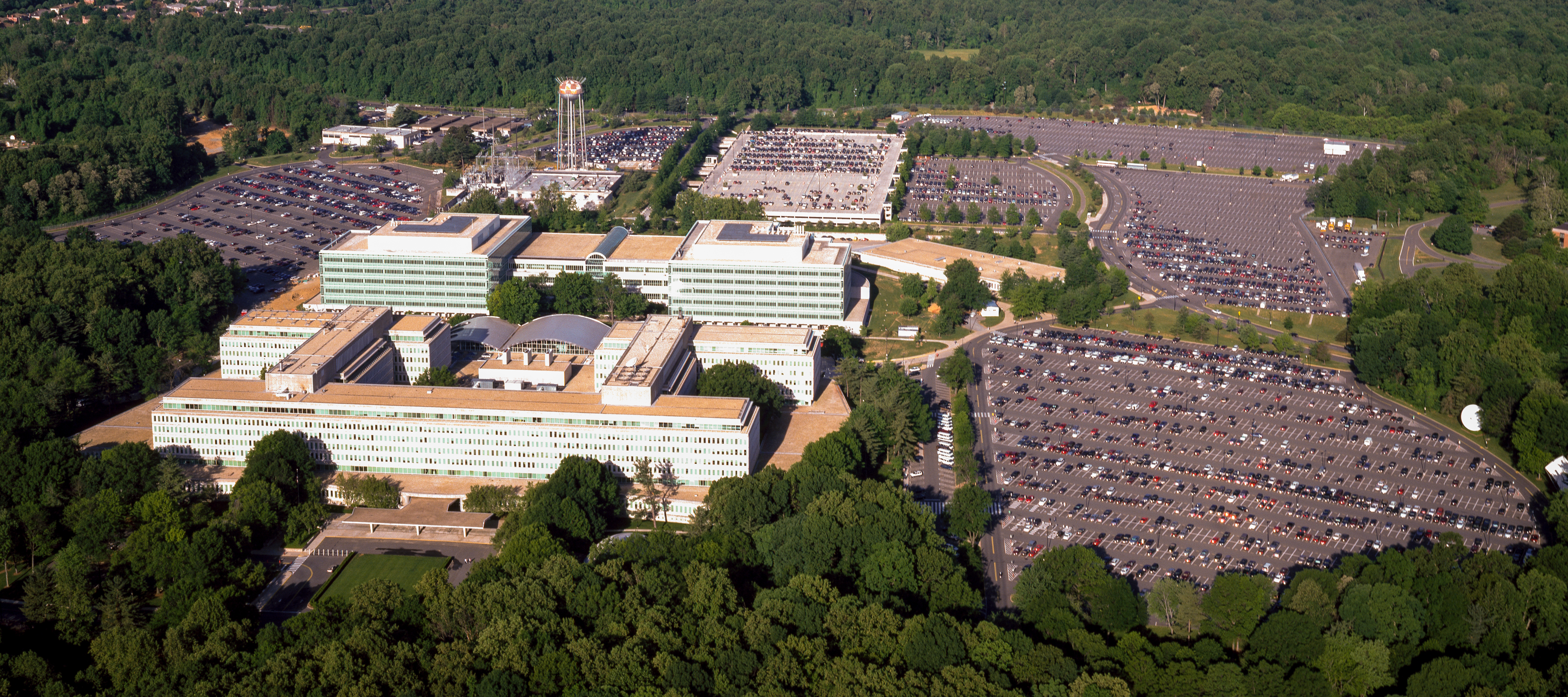
| Aerial view of the Central Intelligence Agency headquarters, Langley, Virginia
( |
|||||||||||||||||||||||||||
|---|---|---|---|---|---|---|---|---|---|---|---|---|---|---|---|---|---|---|---|---|---|---|---|---|---|---|---|
| Autor |
|
||||||||||||||||||||||||||
| Název |
Aerial view of the Central Intelligence Agency headquarters, Langley, Virginia |
||||||||||||||||||||||||||
| Depicted place | Central Intelligence Agency headquarters | ||||||||||||||||||||||||||
| Datum | mezi 1980 a 2006 | ||||||||||||||||||||||||||
| Technika | 1 transparency : color | ||||||||||||||||||||||||||
| Rozměry | 4 x 5 in. or smaller. | ||||||||||||||||||||||||||
| Sbírka |
|
||||||||||||||||||||||||||
| Současné umístění |
Prints and Photographs Division http://hdl.loc.gov/loc.pnp/pp.print |
||||||||||||||||||||||||||
| Poznámky |
|
||||||||||||||||||||||||||
| Zdroj |
|
||||||||||||||||||||||||||
| Svolení (Užití tohoto souboru) |
Rights Advisory: No known restrictions on publication. | ||||||||||||||||||||||||||
| Další verze |
|
||||||||||||||||||||||||||


| | Tento snímek a mnohé další na: OpenStreetMap |
Licence
| This work is from the Carol M. Highsmith Archive collection at the Library of Congress. According to the library, there are no known copyright restrictions on the use of this work. Carol M. Highsmith has stipulated that her photographs are in the public domain. Photographs of sculpture or other works of art may be restricted by the copyright of the artist. |
 |
Historie souboru
Kliknutím na datum a čas se zobrazí tehdejší verze souboru.
| Datum a čas | Náhled | Rozměry | Uživatel | Komentář | |
|---|---|---|---|---|---|
| současná | 22. 4. 2017, 18:17 | | 5 523 × 2 455 (7,57 MB) | Falcorian | User created page with UploadWizard |
Využití souboru
Tento soubor používá následující stránka:
Globální využití souboru
Tento soubor využívají následující wiki:
- Využití na ar.wikipedia.org
- Využití na arz.wikipedia.org
- Využití na ast.wikipedia.org
- Využití na azb.wikipedia.org
- Využití na az.wikipedia.org
- Využití na br.wikipedia.org
- Využití na ca.wikipedia.org
- Využití na ce.wikipedia.org
- Využití na cy.wikipedia.org
- Využití na da.wikipedia.org
- Využití na de.wikipedia.org
- Využití na en.wikipedia.org
- Využití na eo.wikipedia.org
- Využití na eo.wikiquote.org
- Využití na es.wikipedia.org
- Využití na fi.wikipedia.org
- Využití na fr.wikipedia.org
- Využití na fr.wikinews.org
- Využití na ga.wikipedia.org
- Využití na ha.wikipedia.org
- Využití na he.wikipedia.org
- Využití na hu.wikipedia.org
- Využití na id.wikipedia.org
- Využití na it.wikipedia.org
- Využití na ja.wikipedia.org
- Využití na ko.wikipedia.org
- Využití na ky.wikipedia.org
- Využití na lt.wikipedia.org
- Využití na lv.wikipedia.org
- Využití na mn.wikipedia.org
- Využití na ne.wikipedia.org
- Využití na nn.wikipedia.org
- Využití na no.wikipedia.org
- Využití na ro.wikipedia.org
- Využití na ru.wikipedia.org
- Využití na ru.wikinews.org
- Využití na sk.wikipedia.org
Zobrazit další globální využití tohoto souboru.