Soubor:1889 Ewer Map of Nantucket, Massachusetts - Geographicus - Nantucket-ewer-1889.jpg

Původní soubor (4 000 × 1 933 pixelů, velikost souboru: 2,35 MB, MIME typ: image/jpeg)
| Tento soubor pochází z Wikimedia Commons. Níže jsou zobrazeny informace, které obsahuje jeho tamější stránka s popisem souboru. |
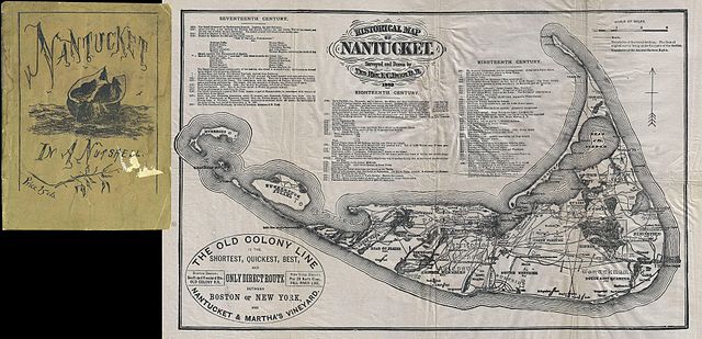
| Historical Map of Nantucket. | ||||||
|---|---|---|---|---|---|---|
| Tvůrce | ||||||
| Název |
Historical Map of Nantucket. |
|||||
| Popis |
English: This attractive map is a reduced version of Reverend F. C. Ewers important map of Nantucket. This variant was issued by the Old Colony Rail line in various formats from roughly 1869 to 1889. Covers the island of Nantucket in superb detail focusing on transportation and communities. Advertises the “Old Colony Line” as the “shortest, Quickest, Best, and Only Direct Route between Boston or New York and Nantucket & Martha’s Vineyard.” Also notes Native American claims to the Island. Features three columns of text breaking down the history of Nantucket from its discovery by Bartholomew Gosnold in 1602 to the laying of the first communications cables between Nantucket and the mainland in 1886. This map was prepared and published by the “Inquirer and Mirror Steam Press” of Nantucket for inclusion in their appealing 1880 pocket guide to the island entitled Nantucket in a Nutshell . The guide, which is includes in this map consists of 36 pages detailing the history, inhabitants, government, religion and trade of the island. It also extols the virtues of Nantucket as a sanitarium, sporting ground, and holiday destination. |
|||||
| Datum | 1889 (dated) | |||||
| Rozměry | výška: 9 in (22,8 cm); šířka: 14 in (35,5 cm) | |||||
| Inventární číslo |
Geographicus link: Nantucket-ewer-1889 |
|||||
| Zdroj/Fotograf |
Nantucket in a Nutshell, 1889.
|
|||||
| Svolení (Užití tohoto souboru) |
|
|||||
Historie souboru
Kliknutím na datum a čas se zobrazí tehdejší verze souboru.
| Datum a čas | Náhled | Rozměry | Uživatel | Komentář | |
|---|---|---|---|---|---|
| současná | 17. 3. 2011, 21:38 | | 4 000 × 1 933 (2,35 MB) | BotMultichill | {{subst:User:Multichill/Geographicus |link=http://www.geographicus.com/P/AntiqueMap/Nantucket-ewer-1889 |product_name=1889 Ewer Map of Nantucket, Massachusetts |map_title=Historical Map of Nantucket. |description=This attractive map is a reduced version o |
Využití souboru
Tento soubor používá následující stránka: