Soubor:World map Strabo.jpg

Velikost tohoto náhledu: 800 × 437 pixelů. Jiná rozlišení: 320 × 175 pixelů | 640 × 350 pixelů | 1 024 × 559 pixelů | 1 280 × 699 pixelů | 3 014 × 1 646 pixelů.
Původní soubor (3 014 × 1 646 pixelů, velikost souboru: 1,49 MB, MIME typ: image/jpeg)
| Tento soubor pochází z Wikimedia Commons. Níže jsou zobrazeny informace, které obsahuje jeho tamější stránka s popisem souboru. |
Popis
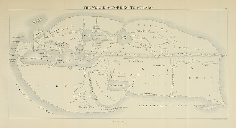
| Popis | 19th century reconstruction of World map according to Strabo (18 A.D.). | ||||||||||||||||||||||||||||||||||||||||||
| Datum | |||||||||||||||||||||||||||||||||||||||||||
| Zdroj | https://archive.org/download/historyofancient02bunb/historyofancient02bunb_orig_jp2.tar/historyofancient02bunb_orig_jp2%2Fhistoryofancient02bunb_orig_0271.jp2 | ||||||||||||||||||||||||||||||||||||||||||
| Autor |
|
||||||||||||||||||||||||||||||||||||||||||
| Svolení (Užití tohoto souboru) |
Public domain | ||||||||||||||||||||||||||||||||||||||||||
| Další verze |
|
||||||||||||||||||||||||||||||||||||||||||


Licence
|
Toto dílo je volné také v zemích, jejichž právní řád chrání majetková autorská práva po dobu života autora a 100 let po jeho smrti. Toto dílo je ve Spojených státech amerických dílem volným (public domain), protože tam bylo registrováno u U.S. Copyright Office nebo zveřejněno před 1. lednem 1929. | |
| Bylo zjištěno, že u tohoto souboru nejsou známa žádná omezení daná autorským právem a právy s ním souvisejícími. | |
Historie souboru
Kliknutím na datum a čas se zobrazí tehdejší verze souboru.
| Datum a čas | Náhled | Rozměry | Uživatel | Komentář | |
|---|---|---|---|---|---|
| současná | 5. 7. 2020, 17:03 | | 3 014 × 1 646 (1,49 MB) | Sette-quattro | higher quality image from https://archive.org/download/historyofancient02bunb/historyofancient02bunb_orig_jp2.tar/historyofancient02bunb_orig_jp2%2Fhistoryofancient02bunb_orig_0271.jp2 |
| 29. 2. 2008, 23:11 |  | 738 × 458 (65 KB) | Anrie | {{Information |Description=19th century reconstruction of World map according to Strabo (18 A.D.). |Source= [http://www.istrianet.org/istria/history/0000-0999AD/strabo/strabo-cartography.htm istrianet.org |Date=1800s (no exact date give) |Author= No autho |
Využití souboru
Tento soubor nepoužívá žádná stránka.
Globální využití souboru
Tento soubor využívají následující wiki:
- Využití na af.wikipedia.org
- Využití na ca.wikipedia.org
- Využití na fy.wikipedia.org
- Využití na kk.wikipedia.org
- Využití na pl.wikipedia.org