Soubor:Norderney Landsat7.png

Velikost tohoto náhledu: 800 × 278 pixelů. Jiná rozlišení: 320 × 111 pixelů | 1 152 × 400 pixelů.
Původní soubor (1 152 × 400 pixelů, velikost souboru: 522 KB, MIME typ: image/png)
| Tento soubor pochází z Wikimedia Commons. Níže jsou zobrazeny informace, které obsahuje jeho tamější stránka s popisem souboru. |
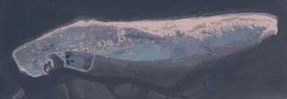
Popis
Deutsch: Aufnahme der deutschen Insel Norderney durch Community Landsat 7.
English: Picture of german island Norderney taken by Community Landsat 7.
Source: NASA World Wind, originally uploaded to de:Bild:Landsat7ney.png by de:Benutzer:Elvaube: 17:47, 21. Jul 2005 . . Elvaube . . 1152 x 400 (534483 Byte) (Beschreibung: Community Landsat 7 Aufnahme von Norderney Quelle: NASA World Wind Lizenz: public domain)
Licence
| This image is in the public domain because it is a screenshot from NASA’s globe software World Wind using a public domain layer, such as Blue Marble, MODIS, Landsat, SRTM, USGS or GLOBE.
|
 |
Historie souboru
Kliknutím na datum a čas se zobrazí tehdejší verze souboru.
| Datum a čas | Náhled | Rozměry | Uživatel | Komentář | |
|---|---|---|---|---|---|
| současná | 29. 12. 2005, 21:42 | 1 152 × 400 (522 KB) | Dabbelju | ==Description== {{de|Aufnahme der deutschen Insel Norderney durch Community Landsat 7.}} {{en|Picture of german island Norderney taken by Community Landsat 7.}} '''Source:''' NASA World Wind, originally uploaded to de:Bild:Landsat7ney.png b |
Využití souboru
Tento soubor používá následující stránka:
Globální využití souboru
Tento soubor využívají následující wiki: