Soubor:Montenegro-un-cs.png

Původní soubor (537 × 613 pixelů, velikost souboru: 162 KB, MIME typ: image/png)
| Tento soubor pochází z Wikimedia Commons. Níže jsou zobrazeny informace, které obsahuje jeho tamější stránka s popisem souboru. |
| Popis |
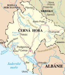
Mapa Černé Hory Map of Montenegro |
| Zdroj | Vlastní dílo |
| Autor | Zirland |
| Další verze | Image:Montenegro-un.png |
This file is in the public domain because permission given by UN as set out below
|
| This image is a map derived from a United Nations map.
Unless stated otherwise, UN maps are to be considered in the public domain. This applies worldwide. UN maps are, in principle, open source material and you can use them in your work or for making your own map. UN requests however that you delete the UN name, logo and reference number upon any modification to the map. Content of your map will be your responsibility. You can state in your publication, if you wish, something like: based on UN map … (map name, map number, revision number and date). See: Geospatial Information Section. And: Geospatial, location data for a better world. |
 |
Historie souboru
Kliknutím na datum a čas se zobrazí tehdejší verze souboru.
| Datum a čas | Náhled | Rozměry | Uživatel | Komentář | |
|---|---|---|---|---|---|
| současná | 6. 5. 2007, 18:24 | | 537 × 613 (162 KB) | Zirland | {{Information |Description=Mapa Černé Hory<br>Map of Montenegro |Source=self-made |Date= |Author= User:Zirland |other_versions=Image:Montenegro-un.png }} {{PD-OSNMap}} |
Využití souboru
Tento soubor používají následující 2 stránky: