Soubor:Mingachevir Reservoir, Azerbaijan.JPG

Velikost tohoto náhledu: 398 × 599 pixelů. Jiná rozlišení: 159 × 240 pixelů | 319 × 480 pixelů | 510 × 768 pixelů | 680 × 1 024 pixelů | 1 361 × 2 048 pixelů | 2 829 × 4 256 pixelů.
Původní soubor (2 829 × 4 256 pixelů, velikost souboru: 2,08 MB, MIME typ: image/jpeg)
| Tento soubor pochází z Wikimedia Commons. Níže jsou zobrazeny informace, které obsahuje jeho tamější stránka s popisem souboru. |
Popis
| Popis |
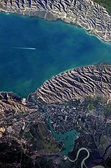
English: This detailed astronaut photograph highlights the southern Mingachevir Reservoir in north-central Azerbaijan. Folded layers of relatively young (less than 5. 3 million years old) sedimentary rock, explosive volcanic products (ash and tuff), and unconsolidated sediments form the grey hills along the northern and southern shorelines of the reservoir (image centre and right). Afternoon sun highlights distinctive parallel patterns in the hills that are the result of water and wind erosion of different rock layers exposed at the surface. The nearby city of Mingachevir (left) is split by the Kur River after it passes through the dam and hydroelectric power station complex at image top centre. The reservoir held approximately 15 billion cubic meters of water at the time this image was taken, with a total engineered capacity of 16 billion cubic meters. The width of the reservoir illustrated here is approximately 8 kilometres; a jet flying over the reservoir left a contrail midway between the shorelines. |
| Datum | |
| Zdroj | NASA Earth Observatory |
| Autor | ISS Expedition 23 crew |
| Pozice fotografa | | Tento snímek a mnohé další na: OpenStreetMap |
|---|
Tento mediální soubor byl katalogizován v Johnsonově vesmírném středisku amerického Národního úřadu pro letectví a kosmonautiku (NASA)pod Photo ID: ISS023-E-35670. Toto oznámení nepopisuje autorskoprávní status tohoto souboru. Stále je vyžadován běžný popisek licence. Další informace najdete na Commons:Licencování. Jiné jazyky:
|
Image captured with a Nikon D3S digital camera, and is provided by the ISS Crew Earth Observations experiment and Image Science & Analysis Laboratory, Johnson Space Center.
Licence
| This file is in the public domain in the United States because it was solely created by NASA. NASA copyright policy states that "NASA material is not protected by copyright unless noted". (See Template:PD-USGov, NASA copyright policy page or JPL Image Use Policy.) | ||
 |
Warnings:
|
| Poznámky | K tomuto souboru existují poznámky: Prohlédnout si poznámky na Commons |
Historie souboru
Kliknutím na datum a čas se zobrazí tehdejší verze souboru.
| Datum a čas | Náhled | Rozměry | Uživatel | Komentář | |
|---|---|---|---|---|---|
| současná | 18. 6. 2018, 12:00 | | 2 829 × 4 256 (2,08 MB) | SteinsplitterBot | Bot: Image rotated by 270° |
| 7. 6. 2010, 18:54 |  | 4 256 × 2 829 (2,09 MB) | Originalwana | {{Information |Description={{en|1=This detailed astronaut photograph highlights the southern Mingachevir Reservoir in north-central Azerbaijan. Folded layers of relatively young (less than 5. 3 million years old) sedimentary rock, explosive volcanic p |
Využití souboru
Tento soubor používá následující stránka:
Globální využití souboru
Tento soubor využívají následující wiki:
- Využití na arz.wikipedia.org
- Využití na azb.wikipedia.org
- Využití na az.wikipedia.org
- Využití na az.wiktionary.org
- Využití na be.wikipedia.org
- Využití na ca.wikipedia.org
- Využití na ceb.wikipedia.org
- Využití na de.wikipedia.org
- Využití na en.wikipedia.org
- Využití na eo.wikipedia.org
- Využití na es.wikipedia.org
- Využití na fa.wikipedia.org
- Využití na fi.wikipedia.org
- Využití na fr.wikipedia.org
- Využití na fy.wikipedia.org
- Využití na he.wikipedia.org
- Využití na hr.wikipedia.org
- Využití na hu.wikipedia.org
- Využití na hy.wikipedia.org
- Využití na id.wikipedia.org
- Využití na ilo.wikipedia.org
- Využití na it.wikipedia.org
- Využití na ja.wikipedia.org
Zobrazit další globální využití tohoto souboru.