Soubor:Map of the Ancient Rome at Caesar time (with conquests)-en.svg

Velikost tohoto PNG náhledu tohoto SVG souboru: 800 × 486 pixelů. Jiná rozlišení: 320 × 195 pixelů | 640 × 389 pixelů | 1 024 × 623 pixelů | 1 280 × 778 pixelů | 2 560 × 1 557 pixelů | 1 674 × 1 018 pixelů.
Původní soubor (soubor SVG, nominální rozměr: 1 674 × 1 018 pixelů, velikost souboru: 2,8 MB)
| Tento soubor pochází z Wikimedia Commons. Níže jsou zobrazeny informace, které obsahuje jeho tamější stránka s popisem souboru. |
Popis
| Popis |
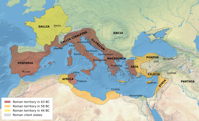
English: Map of the Roman Republic's empire and vassal states, 1st century BC. All labels in Latin. Legend in English. |
| Datum | |
| Zdroj | Vlastní tvorba založená na: Map of the Ancient Rome at Caesar time (with conquests)-fr.svg |
| Autor | User:Historicair, Ifly6 |
| Další verze |
[]
|
-en.svg)
-es.svg)
-fr.svg)
-zh.svg)
-en.svg)
Licence
Já, držitel autorských práv k tomuto dílu, ho tímto zveřejňuji za podmínek následující licence:
Tento soubor podléhá licenci Creative Commons Uveďte autora-Zachovejte licenci 3.0 Unported
- Dílo smíte:
- šířit – kopírovat, distribuovat a sdělovat veřejnosti
- upravovat – pozměňovat, doplňovat, využívat celé nebo částečně v jiných dílech
- Za těchto podmínek:
- uveďte autora – Máte povinnost uvést autorství, poskytnout odkaz na licenci a uvést, pokud jste provedli změny. Toho můžete docílit jakýmkoli rozumným způsobem, avšak ne způsobem naznačujícím, že by poskytovatel licence schvaloval nebo podporoval vás nebo vaše užití díla.
- zachovejte licenci – Pokud tento materiál jakkoliv upravíte, přepracujete nebo použijete ve svém díle, musíte své příspěvky šířit pod stejnou nebo slučitelnou licencí jako originál.
Historie souboru
Kliknutím na datum a čas se zobrazí tehdejší verze souboru.
| Datum a čas | Náhled | Rozměry | Uživatel | Komentář | |
|---|---|---|---|---|---|
| současná | 16. 3. 2023, 07:30 | | 1 674 × 1 018 (2,8 MB) | Ifly6 | add labels for dacia and parthia |
| 16. 3. 2023, 07:26 |  | 1 674 × 1 018 (2,74 MB) | Ifly6 | reproject in gis with natural earth 2. remove unnecessary details. | |
| 1. 5. 2022, 01:56 |  | 2 043 × 1 211 (361 KB) | Ifly6 | really made it all text ; also added veneti label | |
| 1. 5. 2022, 01:48 |  | 2 043 × 1 211 (387 KB) | Ifly6 | update font to sens-serif all and re-type all labels to be in text | |
| 30. 4. 2022, 02:04 |  | 2 043 × 1 211 (557 KB) | Ifly6 | hopefully the city dots will appear ''this time'' | |
| 28. 4. 2022, 21:58 |  | 2 043 × 1 211 (552 KB) | Ifly6 | normalise some text names and sizes. i guess we'll see if the city markers show up this time. | |
| 28. 4. 2022, 21:50 |  | 2 043 × 1 211 (571 KB) | Ifly6 | Uploaded own work with UploadWizard |
Využití souboru
Tento soubor používá následující stránka:
Globální využití souboru
Tento soubor využívají následující wiki:
- Využití na en.wikipedia.org
- Využití na et.wikipedia.org
- Využití na gv.wikipedia.org
- Využití na hr.wikipedia.org
- Využití na ja.wikipedia.org
- Využití na ka.wikipedia.org
- Využití na lt.wikipedia.org
- Využití na ru.wikipedia.org
-en.svg)