Soubor:Lake Chagan - Landsat TM 150.jpg

Velikost tohoto náhledu: 800 × 444 pixelů. Jiná rozlišení: 320 × 178 pixelů | 640 × 356 pixelů | 900 × 500 pixelů.
Původní soubor (900 × 500 pixelů, velikost souboru: 53 KB, MIME typ: image/jpeg)
| Tento soubor pochází z Wikimedia Commons. Níže jsou zobrazeny informace, které obsahuje jeho tamější stránka s popisem souboru. |
Popis
| Popis |
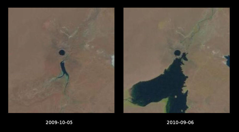
Polski: "Jezioro atomowe" Szagan w 2009 i 2010 roku. Kolisty zbiornik powyżej środka zdjęcia jest kraterem utworzonym przez radziecki test jądrowy w 1965 roku; na zdjęciu z 2010 roku widać, że łączy się on z płytkim zbiornikiem na rzece Szagan, co pozwala na mieszanie się wód. English: Chagan "Atomic Lake" in 2009 and 2010. Circular basin above the center of the image is the crater created by Soviet nuclear test in 1965; on the 2010 image it appears to be connected with a shallow reservoir on Shagan River, allowing water exchange. |
| Datum | |
| Zdroj | Images from USGS: LandsatLook Viewer |
| Autor | USGS/NASA Landsat Program; comparison made by Szczureq |
Licence
| This file is in the public domain in the United States because it was solely created by NASA. NASA copyright policy states that "NASA material is not protected by copyright unless noted". (See Template:PD-USGov, NASA copyright policy page or JPL Image Use Policy.) | ||
 |
Warnings:
|
Historie souboru
Kliknutím na datum a čas se zobrazí tehdejší verze souboru.
| Datum a čas | Náhled | Rozměry | Uživatel | Komentář | |
|---|---|---|---|---|---|
| současná | 20. 6. 2013, 18:30 | | 900 × 500 (53 KB) | Szczureq | User created page with UploadWizard |
Využití souboru
Tento soubor nepoužívá žádná stránka.
Globální využití souboru
Tento soubor využívají následující wiki:
- Využití na be-tarask.wikipedia.org
- Využití na be.wikipedia.org
- Využití na ca.wikipedia.org
- Využití na es.wikipedia.org
- Využití na fr.wikipedia.org
- Využití na hu.wikipedia.org
- Využití na pl.wikipedia.org
- Využití na tr.wikipedia.org
- Využití na uk.wikipedia.org
- Využití na www.wikidata.org