Soubor:Iberian Union Empires.png
Velikost tohoto náhledu: 800 × 370 pixelů. Jiná rozlišení: 320 × 148 pixelů | 640 × 296 pixelů | 1 357 × 628 pixelů.
Původní soubor (1 357 × 628 pixelů, velikost souboru: 25 KB, MIME typ: image/png)
| Tento soubor pochází z Wikimedia Commons. Níže jsou zobrazeny informace, které obsahuje jeho tamější stránka s popisem souboru. |


|
K tomuto obrázku existuje vektorová verze (v SVG). Pokud je lepší, používejte raději tu.
File:Iberian Union Empires.png → File:Iberian Union empires.svg
Podrobnější informace o vektorové grafice najdete na stránce Commons:Transition to SVG. Také si můžete přečíst informace o podpoře formátu SVG v MediaWiki. |
 |
| Popis |
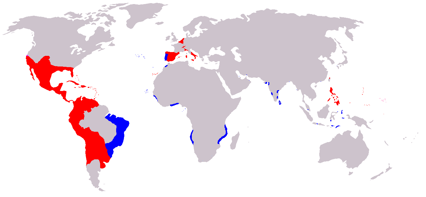
A map of the Spanish and Portuguese Empires in the period of their personal union (1581-1640). Blue: Portuguese Empire; Red: Spanish Empire; |
||
| Zdroj | English Wikipedia, original description is/was here. | ||
| Autor | en:User:Câmara | ||
| Svolení (Užití tohoto souboru) |
|
Historie souboru
Kliknutím na datum a čas se zobrazí tehdejší verze souboru.
| Datum a čas | Náhled | Rozměry | Uživatel | Komentář | |
|---|---|---|---|---|---|
| současná | 20. 11. 2019, 09:00 | | 1 357 × 628 (25 KB) | Geographyinitiative | Added Spanish Formosa |
| 4. 1. 2009, 17:05 |  | 1 357 × 628 (22 KB) | The Red Hat of Pat Ferrick | Trim size of Portuguese colonies, remove "claims" areas. | |
| 12. 7. 2007, 18:32 |  | 1 357 × 628 (38 KB) | Gveret Tered | {{Information |Description==A map of the Spanish and Portuguese Empires in the period of their personal union (1581-1640). == Licensing ==. |Source=[http://en.wikipedia.org English Wikipedia], original description is/was [[:en:Image:Iberian Union Empires. |
Využití souboru
Tento soubor používá následující stránka:
Globální využití souboru
Tento soubor využívají následující wiki:
- Využití na ar.wikipedia.org
- Využití na ast.wikipedia.org
- Využití na azb.wikipedia.org
- Využití na be.wikipedia.org
- Využití na ca.wikipedia.org
- Využití na da.wikipedia.org
- Využití na de.wikipedia.org
- Využití na en.wikipedia.org
- Využití na es.wikipedia.org
- Využití na fa.wikipedia.org
- Využití na fr.wikipedia.org
- Využití na gl.wikipedia.org
- Využití na he.wikipedia.org
- Využití na hu.wikipedia.org
- Využití na io.wikipedia.org
- Využití na it.wikipedia.org
- Využití na ja.wikipedia.org
Zobrazit další globální využití tohoto souboru.