Soubor:Gibraltar-nasa-pd.jpg
Větší rozlišení není k dispozici
Gibraltar-nasa-pd.jpg (600 × 360 pixelů, velikost souboru: 49 KB, MIME typ: image/jpeg)
| Tento soubor pochází z Wikimedia Commons. Níže jsou zobrazeny informace, které obsahuje jeho tamější stránka s popisem souboru. |
Popis
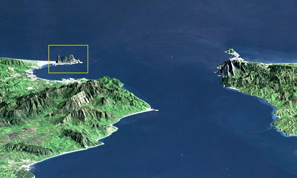
| Popis |
Galego: Estreito de Xibraltar – A súa anchura é de 15 km. Á esquerda, España e a Rocha (no marco amarelo). Á dereita, Marrocos. Sobre a punta desta parte de territorio marroquí que descende cara ao Mediterráneo atópase o enclave español de Ceuta, cidade autónoma comercial e de guarnición de 74.000 habitantes. |
|||||
| Datum | ||||||
| Zdroj | [1] | |||||
| Autor | Basilio 15:39, 10 January 2007 (UTC) | |||||
| Svolení (Užití tohoto souboru) |
|
|||||
| Další verze |
|


Historie souboru
Kliknutím na datum a čas se zobrazí tehdejší verze souboru.
| Datum a čas | Náhled | Rozměry | Uživatel | Komentář | |
|---|---|---|---|---|---|
| současná | 14. 6. 2012, 02:04 | | 600 × 360 (49 KB) | Saibo | Reverted to version as of 15:39, 10 January 2007. Please upload under a new name. Uses may refer to the orientation. The current one is not totally and clearly wrong. |
| 13. 6. 2012, 16:30 |  | 352 × 600 (49 KB) | Rotatebot | Bot: Image rotated by 90° | |
| 10. 1. 2007, 17:39 |  | 600 × 360 (49 KB) | Oilisab | {{Information |Description= Détroit de Gigraltar |Source=[http://www.latinreporters.com/espagnegib21092006photo.html] |Date=2007 |Author=~~~~ |Permission={{PD}} |other_versions= }} |
Využití souboru
Tento soubor používá následující stránka:
Globální využití souboru
Tento soubor využívají následující wiki:
- Využití na en.wikipedia.org
- Využití na es.wikipedia.org
- Využití na gl.wikipedia.org
- Využití na mt.wikipedia.org
- Využití na nl.wikipedia.org
- Využití na uk.wikipedia.org