Soubor:France-Constituent-Lands.png

Velikost tohoto náhledu: 606 × 599 pixelů. Jiná rozlišení: 243 × 240 pixelů | 485 × 480 pixelů | 777 × 768 pixelů | 1 035 × 1 024 pixelů | 2 071 × 2 048 pixelů | 3 337 × 3 300 pixelů.
Původní soubor (3 337 × 3 300 pixelů, velikost souboru: 382 KB, MIME typ: image/png)
| Tento soubor pochází z Wikimedia Commons. Níže jsou zobrazeny informace, které obsahuje jeho tamější stránka s popisem souboru. |

|
Tento obrázek (skupina map) by měl být vytvořen pomocí vektorové grafiky jako SVG soubor. To má několik výhod; podrobnosti najdete na stránce Commons:Media for cleanup. Je-li SVG verze tohoto obrázku již k dispozici, prosím nahrajte ji. Po nahrání nahraďte tuto šablonu šablonou {{Vector version available|jméno nového obrázku.svg}}.
|
Popis
| Popis |
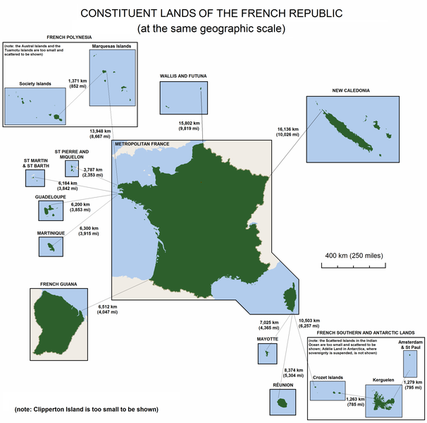
English: The constituent lands of the French Republic |
| Datum | |
| Zdroj | Vlastní dílo |
| Autor | Godefroy |
| Další verze |
|

Licence
Já, držitel autorských práv k tomuto dílu, ho tímto zveřejňuji za podmínek následujících licencí:

|
Tento dokument smí být kopírován, šířen nebo upravován podle podmínek Svobodné licence GNU pro dokumenty verze 1.2 nebo libovolné vyšší verze publikované nadací Free Software Foundation. Dokument nemá neměnné části ani texty na předním či zadním přebalu. Kopie textu licence je k dispozici v oddíle nazvaném GNU Free Documentation License. |
| Tento soubor podléhá licenci Creative Commons Uveďte autora-Zachovejte licenci 3.0 Unported | ||
| ||
| Tato licenční šablona byla k tomuto souboru přidána v rámci změny licencování. |
Můžete si zvolit libovolnou z těchto licencí.
Historie souboru
Kliknutím na datum a čas se zobrazí tehdejší verze souboru.
| Datum a čas | Náhled | Rozměry | Uživatel | Komentář | |
|---|---|---|---|---|---|
| současná | 7. 11. 2010, 17:47 | | 3 337 × 3 300 (382 KB) | Rosss | Moved French language map to a separate file |
| 6. 9. 2010, 04:58 |  | 3 337 × 3 300 (299 KB) | Hypersite | Correction a few mistakes and showing of forgotten territories. -- Correction de petites erreurs et ajouts de territoires oublié. | |
| 17. 4. 2008, 17:52 |  | 3 337 × 3 300 (382 KB) | Godefroy~commonswiki | {{Information |Description= The constituent lands of the French Republic |Source=self-made |Date= April 17, 2008 |Author= Godefroy |Permission= |other_versions= }} |
Využití souboru
Tento soubor používají následující 2 stránky:
Globální využití souboru
Tento soubor využívají následující wiki:
- Využití na an.wikipedia.org
- Využití na ast.wikipedia.org
- Využití na br.wikipedia.org
- Využití na de.wikipedia.org
- Využití na en.wikipedia.org
- Využití na en.wikibooks.org
- Využití na es.wikipedia.org
- Využití na et.wikipedia.org
- Využití na eu.wikipedia.org
- Využití na fa.wikipedia.org
- Využití na fr.wikipedia.org
- Využití na gl.wikipedia.org
- Využití na he.wikipedia.org
- Využití na hi.wikipedia.org
- Využití na hy.wikipedia.org
- Využití na id.wikipedia.org
- Využití na ja.wikipedia.org
- Využití na ka.wikipedia.org
- Využití na km.wikipedia.org
- Využití na lfn.wikipedia.org
- Využití na lld.wikipedia.org
- Využití na lv.wikipedia.org
- Využití na ms.wikipedia.org
- Využití na nn.wikipedia.org
- Využití na no.wikipedia.org
- Využití na pdc.wikipedia.org
- Využití na pt.wikipedia.org
- Využití na ro.wikipedia.org
Zobrazit další globální využití tohoto souboru.