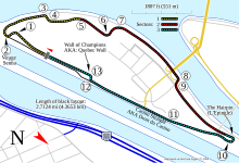
Soubor:Circuit Gilles Villeneuve.png

Velikost tohoto náhledu: 800 × 243 pixelů. Jiná rozlišení: 320 × 97 pixelů | 1 520 × 462 pixelů.
Původní soubor (1 520 × 462 pixelů, velikost souboru: 85 KB, MIME typ: image/png)
Historie souboru
Kliknutím na datum a čas se zobrazí tehdejší verze souboru.
| Datum a čas | Náhled | Rozměry | Uživatel | Komentář | |
|---|---|---|---|---|---|
| současná | 9. 6. 2008, 05:40 | 1 520 × 462 (85 KB) | Will Pittenger | {{Information |Description={{en|1=Track map for w:Circuit Gilles Villeneuve. This PNG version of image:Circuit Gilles Villeneuve.svg is for those with browsers like IE7 that don't support SVG.}} |Source=Own work by uploader |Author=[[User:Will |
Využití souboru
Tento soubor používá následujících 29 stránek:
- Formule 1 v roce 1978
- Formule 1 v roce 1979
- Formule 1 v roce 1980
- Formule 1 v roce 1981
- Formule 1 v roce 1982
- Formule 1 v roce 1983
- Formule 1 v roce 1984
- Formule 1 v roce 1985
- Formule 1 v roce 1986
- Formule 1 v roce 1988
- Formule 1 v roce 1989
- Formule 1 v roce 1990
- Formule 1 v roce 1991
- Formule 1 v roce 1992
- Formule 1 v roce 1993
- Formule 1 v roce 1994
- Formule 1 v roce 1995
- Formule 1 v roce 1996
- Formule 1 v roce 1997
- Formule 1 v roce 1998
- Formule 1 v roce 1999
- Formule 1 v roce 2000
- Formule 1 v roce 2001
- Formule 1 v roce 2002
- Formule 1 v roce 2003
- Formule 1 v roce 2004
- Formule 1 v roce 2005
- Formule 1 v roce 2006
- Formule 1 v roce 2007
Globální využití souboru
Tento soubor využívají následující wiki:
- Využití na fi.wikipedia.org
- Využití na fr.wikipedia.org
- Využití na pl.wikipedia.org
- Využití na ru.wikipedia.org
- Využití na sl.wikipedia.org
