Soubor:Central Tien Shan, China.JPG

Původní soubor (4 288 × 2 850 pixelů, velikost souboru: 1,92 MB, MIME typ: image/jpeg)
| Tento soubor pochází z Wikimedia Commons. Níže jsou zobrazeny informace, které obsahuje jeho tamější stránka s popisem souboru. |
Popis
| Popis |
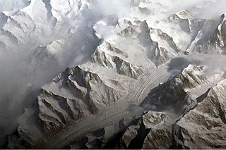
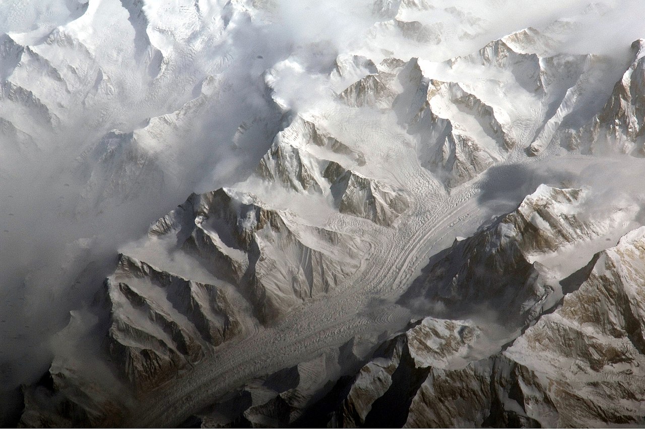
English: This astronaut photograph provides a view of the central Tien Shan, about 64 kilometres east of where the borders of China, Kyrgyzstan, and Kazakhstan meet.
While the image looks like it might have been taken from an airplane, it was taken from the International Space Station (ISS) at an altitude of 341 kilometres. The altitude plus the horizontal distance from the site—ISS was approximately 304 kilometres to the south-west—produces an oblique view. This angle, together with shadowing of valleys, accentuates the mountainous topography. Two types of glaciers are visible in the image; cirque glaciers occupy amphitheater-like depressions on the upper slopes of the mountains, and feed ice down-slope to aggregate into large valley glaciers such as the one at image centre. Low clouds obscure an adjacent valley and glaciers to the north (upper left). Two high peaks of the central Tien Shan are identifiable in the image. Xuelian Feng has a summit of 6, 527 meters above sea level. To the east, the aptly-named Peak 6231 has a summit 6,231 meters above sea level. |
| Datum | |
| Zdroj | NASA Earth Observatory |
| Autor | ISS Expedition 27 crew |
| Pozice fotografa | | Tento snímek a mnohé další na: OpenStreetMap |
|---|
Tento mediální soubor byl katalogizován v Johnsonově vesmírném středisku amerického Národního úřadu pro letectví a kosmonautiku (NASA)pod Photo ID: ISS027-E-5274. Toto oznámení nepopisuje autorskoprávní status tohoto souboru. Stále je vyžadován běžný popisek licence. Další informace najdete na Commons:Licencování. Jiné jazyky:
|
Image acquired with a Nikon D2Xs digital camera using an 800 mm lens, and is provided by the ISS Crew Earth Observations experiment and Image Science & Analysis Laboratory, Johnson Space Center.
Licence
| This file is in the public domain in the United States because it was solely created by NASA. NASA copyright policy states that "NASA material is not protected by copyright unless noted". (See Template:PD-USGov, NASA copyright policy page or JPL Image Use Policy.) | ||
 |
Warnings:
|
| Poznámky | K tomuto souboru existují poznámky: Prohlédnout si poznámky na Commons |
Historie souboru
Kliknutím na datum a čas se zobrazí tehdejší verze souboru.
| Datum a čas | Náhled | Rozměry | Uživatel | Komentář | |
|---|---|---|---|---|---|
| současná | 28. 3. 2011, 12:58 | | 4 288 × 2 850 (1,92 MB) | Originalwana | {{Information |Description ={{en|1=This astronaut photograph provides a view of the central Tien Shan, about 64 kilometres east of where the borders of China, Kyrgyzstan, and Kazakhstan meet. While the image looks like it might have been taken |
Využití souboru
Tento soubor používá následující stránka:
Globální využití souboru
Tento soubor využívají následující wiki:
- Využití na ast.wikipedia.org
- Využití na de.wikipedia.org
- Využití na es.wikipedia.org
- Využití na fi.wikipedia.org
- Využití na gl.wikipedia.org
- Využití na he.wikipedia.org
- Využití na hr.wikipedia.org
- Využití na ml.wikipedia.org
- Využití na mr.wikipedia.org
- Využití na sr.wikipedia.org
- Využití na ug.wikipedia.org
- Využití na uk.wikipedia.org
- Využití na www.wikidata.org