Soubor:Bog Asphodel - geograph.org.uk - 1402752.jpg
Bog_Asphodel_-_geograph.org.uk_-_1402752.jpg (640 × 480 pixelů, velikost souboru: 118 KB, MIME typ: image/jpeg)
| Tento soubor pochází z Wikimedia Commons. Níže jsou zobrazeny informace, které obsahuje jeho tamější stránka s popisem souboru. |
Popis
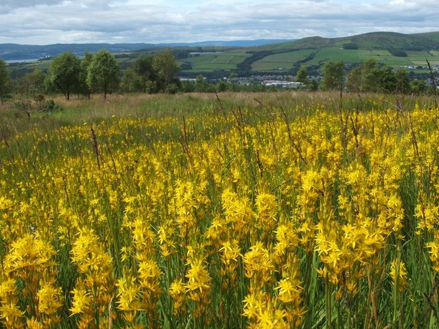
| Popis |
English: Bog Asphodel This is a closer view of some of the flowers that make up an extensive patch of Bog Asphodel (Narthecium ossifragum) on the grassy moors below Pappert Hill: 1402750.
This is a native species, found in bogs and other wet acidic habitats. After flowering, the dried-up remnants of the plant retain a strong orange-yellow colouring for quite some time. The specific name 'ossifragum' means 'bone-breaker'; as is explained in Richard Mabey's "Flora Britannica", that name is indirectly related to the habitat in which the plant is found: "it derives from the belief that grazing the plant made the bones of sheep brittle – though it was not bog asphodel which caused this, but the sour calcium-poor pastures in which it occurs". As for the background, a small part of the River Clyde can be seen at the far left. Slightly to the left of centre, visible as little more than a thin pale-blue line near the top of a hill, is Carman Reservoir. The hills to the right of centre are Carman Hill and Overton Muir. |
| Datum | |
| Zdroj | From geograph.org.uk |
| Autor | Lairich Rig |
| Uveďte autora (vyžadováno licencí) | Lairich Rig / Bog Asphodel / |
| Pozice fotografa | | Tento snímek a mnohé další na: OpenStreetMap |
|---|
_heading:247.00&language=cs)
| Pozice objektu | | Tento snímek a mnohé další na: OpenStreetMap |
|---|
_heading:247.00&language=cs)
Licence

|
This image was taken from the Geograph project collection. See this photograph's page on the Geograph website for the photographer's contact details. The copyright on this image is owned by Lairich Rig and is licensed for reuse under the Creative Commons Attribution-ShareAlike 2.0 license.
|
- Dílo smíte:
- šířit – kopírovat, distribuovat a sdělovat veřejnosti
- upravovat – pozměňovat, doplňovat, využívat celé nebo částečně v jiných dílech
- Za těchto podmínek:
- uveďte autora – Máte povinnost uvést autorství, poskytnout odkaz na licenci a uvést, pokud jste provedli změny. Toho můžete docílit jakýmkoli rozumným způsobem, avšak ne způsobem naznačujícím, že by poskytovatel licence schvaloval nebo podporoval vás nebo vaše užití díla.
- zachovejte licenci – Pokud tento materiál jakkoliv upravíte, přepracujete nebo použijete ve svém díle, musíte své příspěvky šířit pod stejnou nebo slučitelnou licencí jako originál.
Historie souboru
Kliknutím na datum a čas se zobrazí tehdejší verze souboru.
| Datum a čas | Náhled | Rozměry | Uživatel | Komentář | |
|---|---|---|---|---|---|
| současná | 1. 3. 2011, 13:49 | | 640 × 480 (118 KB) | GeographBot | == {{int:filedesc}} == {{Information |description={{en|1=Bog Asphodel This is a closer view of some of the flowers that make up an extensive patch of Bog Asphodel (Narthecium ossifragum) on the grassy moors below Pappert Hill: 1402750. This is a na |
Využití souboru
Tento soubor používá následující stránka:
Globální využití souboru
Tento soubor využívají následující wiki:
- Využití na be.wikipedia.org
- Využití na en.wikipedia.org
- Využití na fr.wikivoyage.org
- Využití na id.wikipedia.org
- Využití na it.wikipedia.org
- Využití na nn.wikipedia.org
- Využití na uk.wikipedia.org
- Využití na vi.wikipedia.org