Soubor:Alegranza 3D version 1.gif
Větší rozlišení není k dispozici
Alegranza_3D_version_1.gif (300 × 214 pixelů, velikost souboru: 6,48 MB, MIME typ: image/gif, ve smyčce, 180 snímků, 11 s)
| Tento soubor pochází z Wikimedia Commons. Níže jsou zobrazeny informace, které obsahuje jeho tamější stránka s popisem souboru. |
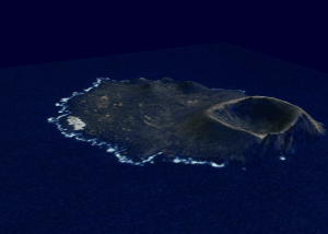
Popis
| Popis |
Español: Isla Alegranza en el archipiélago canario (España), 3D. Imagen realizada con datos SRTM proporcionados gratuitamente por la NASA. English: Alegranza Island in the Canary archipelago (Spain), 3D. Image made with SRTM data freely provided by NASA. Deutsch: Insel Alegranza im Kanarischen Archipel (Spanien), 3D. Bild erstellt mit SRTM-Daten, die kostenlos von der NASA zur Verfügung gestellt wurden. Română: Insula Alegranza din arhipelagul Canarelor (Spania), 3D. Imagine realizata cu date SRTM furnizate liber de NASA. |
| Datum | |
| Zdroj | Topographic data SRTM from NASA and World Imagery |
| Autor | Asybaris01 |
Licence
| This file is in the public domain in the United States because it was solely created by NASA. NASA copyright policy states that "NASA material is not protected by copyright unless noted". (See Template:PD-USGov, NASA copyright policy page or JPL Image Use Policy.) | ||
 |
Warnings:
|
Historie souboru
Kliknutím na datum a čas se zobrazí tehdejší verze souboru.
| Datum a čas | Náhled | Rozměry | Uživatel | Komentář | |
|---|---|---|---|---|---|
| současná | 8. 7. 2011, 21:33 | | 300 × 214 (6,48 MB) | Asybaris01 | {{Information |Description ={{ro|1=dd}} |Source ={{own}} |Author =Asybaris01 |Date =jul 2011 |Permission = |other_versions = }} Category:Canary Islands |
Využití souboru
Tento soubor používá následující stránka:
Globální využití souboru
Tento soubor využívají následující wiki:
- Využití na ast.wikipedia.org
- Využití na ca.wikipedia.org
- Využití na ceb.wikipedia.org
- Využití na en.wikipedia.org
- Využití na es.wikipedia.org
- Využití na es.wikivoyage.org
- Využití na eu.wikipedia.org
- Využití na fr.wikipedia.org
- Využití na hy.wikipedia.org
- Využití na it.wikipedia.org
- Využití na ja.wikipedia.org
- Využití na no.wikipedia.org
- Využití na pl.wikipedia.org
- Využití na pt.wikipedia.org
- Využití na uk.wikipedia.org
- Využití na www.wikidata.org
- Využití na zh.wikipedia.org